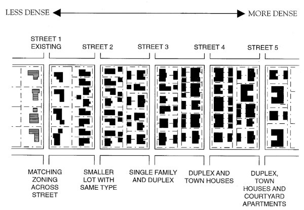
Understanding the Tenets of Sustainable Urbanism


Click image to enlarge
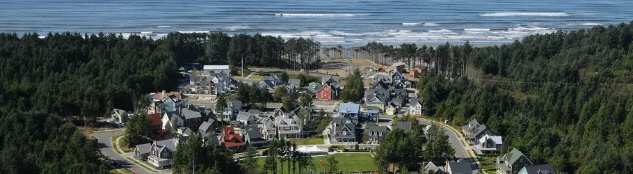
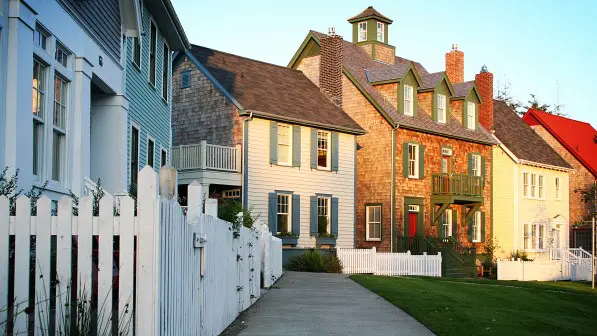
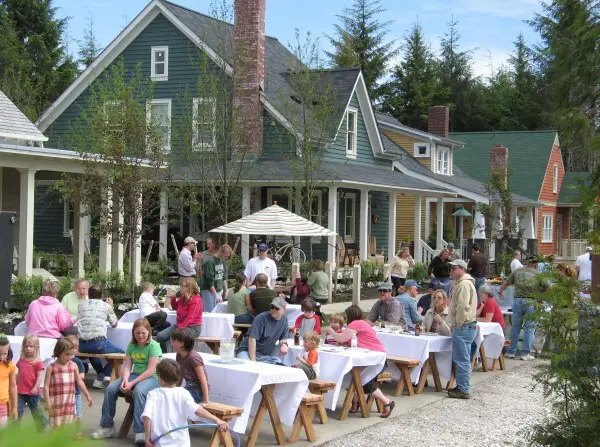
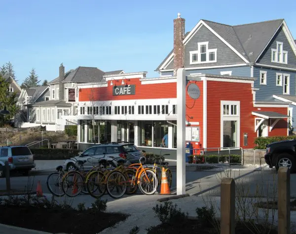
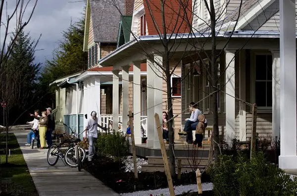
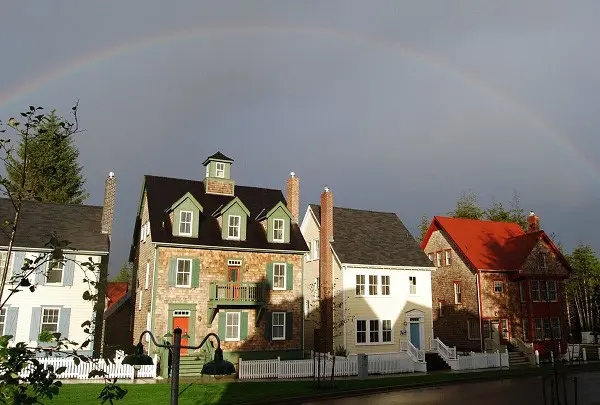
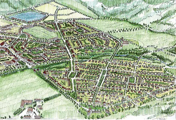
Seabrook
The new town of Seabrook nestles into the wind-swept trees on a bluff overlooking Washington’s Pacific Coast. We designed the new town and continue as its lead Town Planner with ongoing neighborhoods updates and additions.
The town was first conceived in 2002 while touring the Oregon and Washington Coasts searching for the right site with the Town Founder, Casey Roloff, and his family.
Leading the Design Charrette
We led a team of planners, civil and traffic engineers, architects, and landscape designers in a week-long Charrette at the site. We created the Master Plan, Form-Based Code, perspective renderings, building types, and planning diagrams. We conducted public meetings at the local firehouse during the coming months, presenting the plans for the new town, and gathering knowledge of the local culture. We continued touring the most valued towns along the coast, studying and photographing the region’s vernacular buildings and landscape. The plan for the new town received unanimous approval when first presented to the Gray’s Harbor Planning Commission.
Creating the Form-Based Codes and Leading Building Design
Seabrook is designed with a rich mix of home choices for different family types and incomes, in addition to local shopping, recreation, and employment. We created the Form-Based Code that guides the design of all the buildings, in addition to designing many of the core housing stock offered by Seabrook. The Code defined building form, massing, frontage types, placement on the lots, carriage houses, landscape elements, material palette window proportions, eave details, water table details, etc.
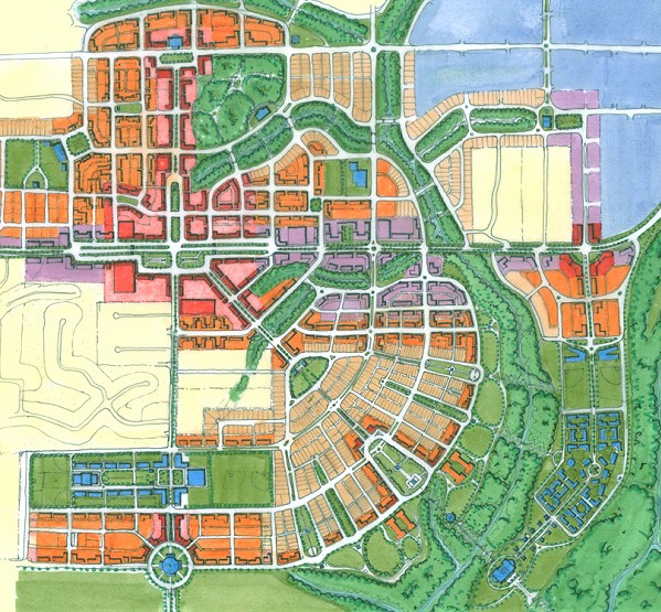
The initial town plan contains over 400 residences on 88 acres. On an additional several hundred acres, which was assembled by the development company at the start, we recently planned new agrarian villages that will have livestock and food-producing gardens.
Sustainable Site Design and Town Planning
Seabrook is planned as a model for sustainable community building. Up to 35% of the initial 88-acre site is managed as preserved forest, wetlands, stream corridors, and parkland. We concentrated the development footprint into intimate lots while creating active parks, plazas, and greens. While there is a gradation of smaller town-center to larger town-edge lots, the majority of open space is maintained in the public realm, and less in the private lots. Many of the lanes are paved with a narrow drive lane and casual parking on crushed oyster shell edges. On some streets houses face onto walking and biking paths without cars (they are to the rear off of alleyways.
Houses and shops on Seabrook Avenue and Main Street view through preserved natural glens out to the Pacific. The houses face promenades with crushed oyster shell paths for the public to enjoy a walk along ocean bluffs. Crescent Park is the central gathering place for festivals, and evening bonfires.
Seabrook is designed to connect all its residents with the valuable resources of the ocean, beach, streams, and wetlands that envelop the community. A ‘green network’ of community greens, forest parks, habitat preserves, promenades, boardwalks, and trails surround and run through the town, allowing complete public enjoyment of streams, wetland preserves, bluffs, beaches, and deep forests.
Location
Client
Casey Roloff, Seabrook Land Company
Type
Sustainable New Town Planning, Urban Design Codes, Building Design
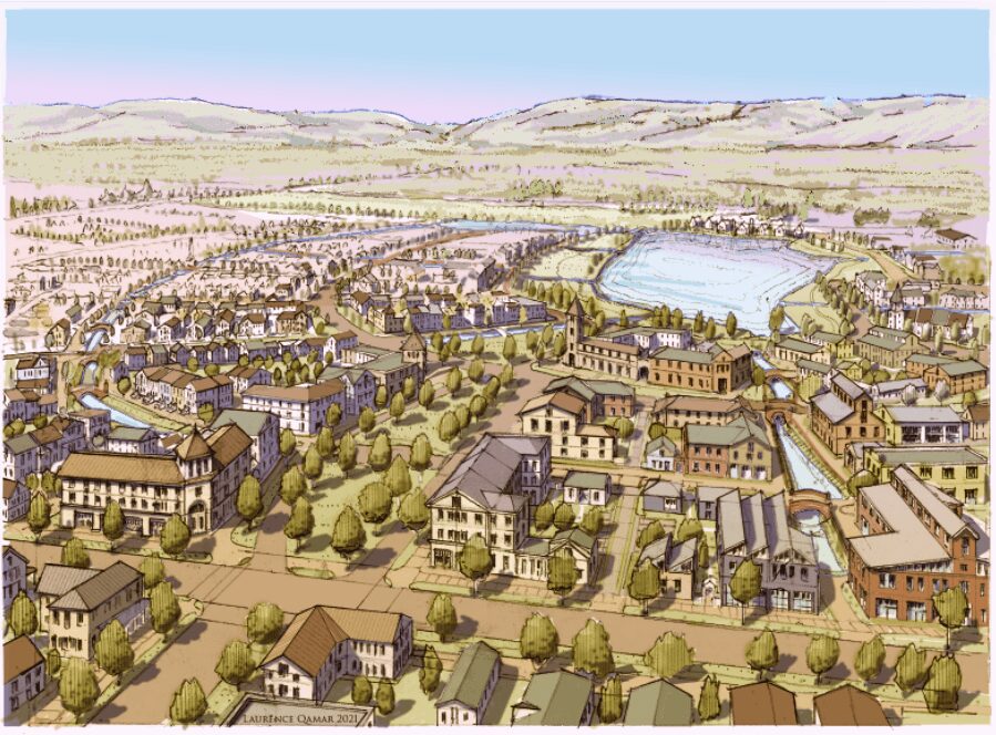
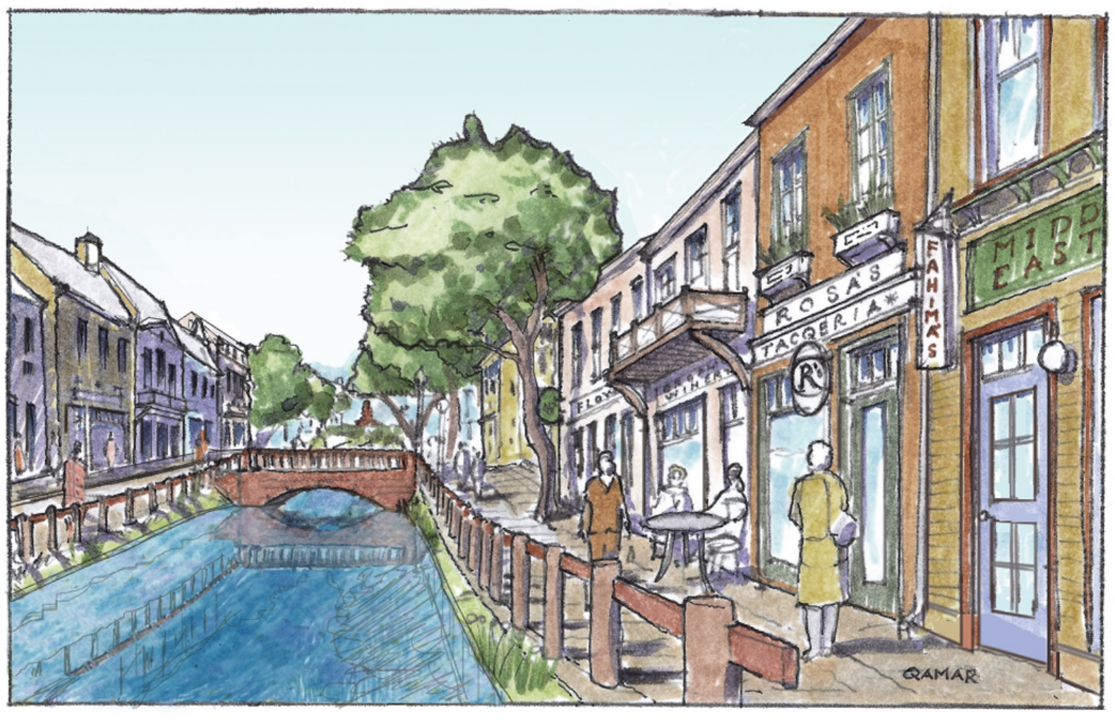
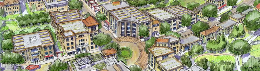
THE CANALS OF ELLENSBURG
Laurence Qamar is leading the design of this new walkable, mixed-use neighborhood on a 200+ acre site near the southern edge of Ellensburg, WA. With two existing ponds on site, and a still functioning agricultural irrigation system, we are creating a networks of greenways with flowing waterways running from the edges of the site into the central pond.
A mixed-use main street with apartments above shops and mid-block parking behind is located where we realigned existing offsite edge roads to flow through the site in order to "feed the retail". A Maker's District is located adjacent to the main street where small light industrial craft people in the artisan food, beverage, building, and micro-food growing communities can foster new businesses.
A unique planning and development pattern of streets and blocks is implemented throughout the new community in which every other street is either a full greenway without cars, or a limited auto laneway (called a woonerf in Holland). This system is supported with the use of rear service lanes so that all homes and businesses have immediate access in the back.
Team members include Michael Mehaffy of Structura Naturalis for planning, Paul Crabtree PE for cilvil engineering, Parametrix for landscape.


Click image to enlarge


Click image to enlarge
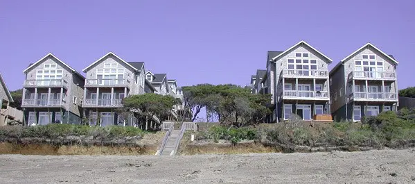
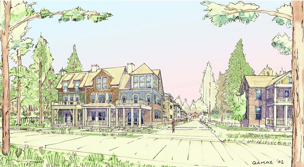
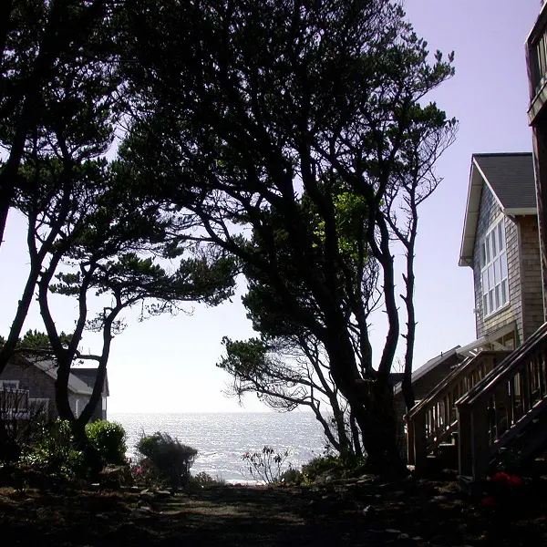
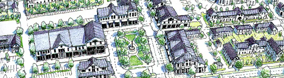
Bella Beach
Bella Beach is a new oceanfront neighborhood on Oregon's Pacific Coast where people work, shop, meet their neighbors, and recreate all within a close walk of their homes. The 15-acre mixed-use neighborhood spans a 1/4 mile from the Pacific Coast Highway to the ocean. Laurence Qamar provided neighborhood master planning and architectural services. The value of each of the 70+ home sites was increased by providing convenient pedestrian access to the ocean, a network of Cottage Greens, corner stores with homes above, and preserved stands of Shore Pine. The "Ocean Mews" is a pedestrian gateway with preserved native pines for residents and the general public to access the beach. Bella is a compact model of a sustainable community on a relatively small infill site using previous pathway and low-impact rainwater infiltration techniques.
New additions to Bella Beach in Phases 2 and 3 include the Neighborhood Green at the entry, the Courtyard Townhouses, and several oceanfront houses. Laurence Qamar has planned the additions and designed the new cottages, townhouses, community building, and a bed & breakfast with a ground floor cafe.
With these additions Bella Beach will establish itself as an authentic oceanside neighborhood where people work, shop, meet their neighbors, and recreate all within close walks of their homes.
Location
Client
Current Development, Casey Roloff
Type
New Neighborhood Infill, Housing, and Live/work Design, Waterfront
Click image to enlarge


Click image to enlarge
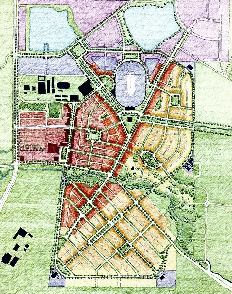
Damascus
The 21,000-acre regional sector master plan for the expansion of the Portland Metro Urban Growth Boundary (UGB) is designed to contribute significantly to the necessary housing/employment balance for the coming 20 years within the greater Portland Metro area. Laurence Qamar worked as a primary Urban Designer on a multi-disciplinary consultant team with State, Regional, County, and local officials, transportation engineers, ecologists, retail strategists, and land-use planners. Laurence established a regional growth pattern of new towns and villages nestled among preserved wooded hills and farm belts. The principles of Smart Growth are integrated into the master plan by first establishing a pattern of interconnected, mixed-use neighborhoods. The master plan emphasizes a fine-grained network of smaller streets to serve the region as an alternative to relying only on collectors, arterials, and highways. The optimal locations of commercial and employment centers are carefully considered to serve the existing and future neighborhoods. Farming green belts and wildlife corridors were allocated as edges to the newly established villages. Laurence also produced a series of aerial renderings of future village types for various locations in the landscape as part of the process of developing the new city’s first development code.
Location
Client
Joe Dills, OTAK, and Anita Yap, City of Damascus
Type
Sustainable New Town Planning, Transportation Networking, Community Typology Studies
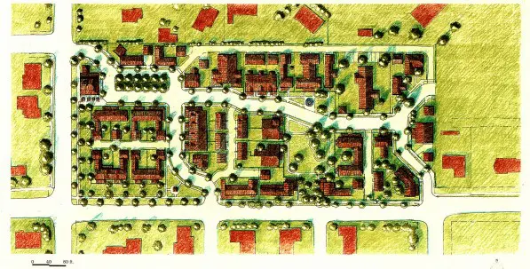
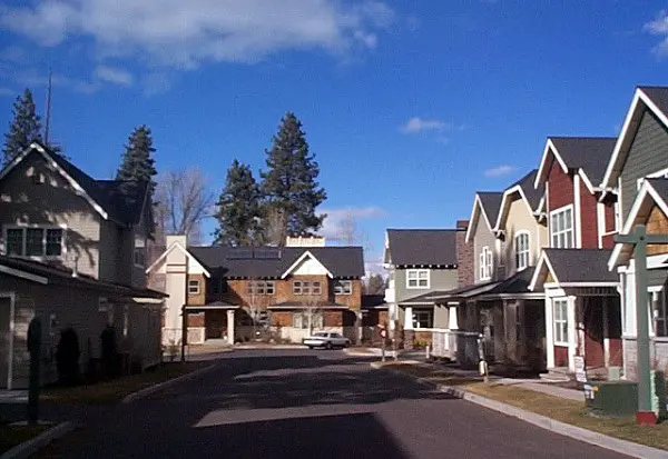
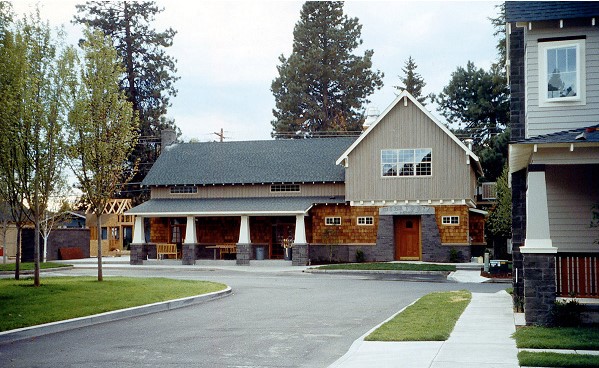
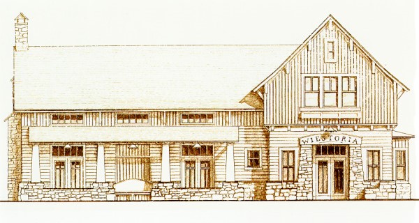
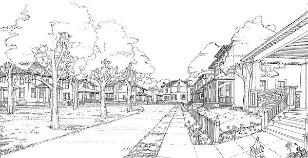
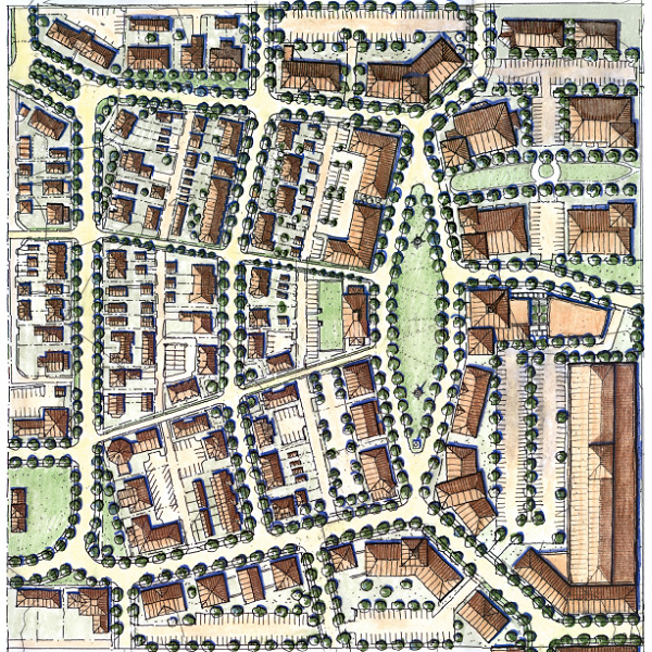
Village Weistoria
Village Weistoria is a seven-acre neighborhood addition in Bend, OR. The new neighborhood infill contains a Meeting House, cottages, double houses, and row houses gathered around picturesque lanes and preserved open space greens and towering conifers. The Meeting House serves as a branch post office, a cafe, a lending library, and a meeting hall for residents and the general public. The opportunity for neighborly interaction is encouraged through the design of the streets, lanes, and sidewalks lined with front porches and shade trees. All the streets are designed as narrow queuing streets, which naturally enforce the slowing of traffic while providing sufficient on-street parking. Laurence Qamar designed the overall street layout, lots, street sections, landscaping, and building codes. The codes regulate the placement of buildings on their lots, the size and orientation of front porches, on-site parking, and a broad pallet of materials and architectural details for all buildings.
Location
Client
Village Development, Kevin Rea
Type
New Neighborhood Infill, Urban and Architectural Standards, Civic Building Architectural Design

Click image to enlarge
Click image to enlarge
Village Weistoria
Village Weistoria is a seven-acre neighborhood addition in Bend, OR. The new neighborhood infill contains a Meeting House, cottages, double houses, and row houses gathered around picturesque lanes and preserved open space greens and towering conifers. The Meeting House serves as a branch post office, a cafe, a lending library, and a meeting hall for residents and the general public. The opportunity for neighborly interaction is encouraged through the design of the streets, lanes, and sidewalks lined with front porches and shade trees. All the streets are designed as narrow queuing streets, which naturally enforce the slowing of traffic while providing sufficient on-street parking. Laurence Qamar designed the overall street layout, lots, street sections, landscaping, and building codes. The codes regulate the placement of buildings on their lots, the size and orientation of front porches, on-site parking, and a broad pallet of materials and architectural details for all buildings.
Location
Client
Village Development, Kevin Rea
Type
New Neighborhood Infill, Urban and Architectural Standards, Civic Building Architectural Design


Click image to enlarge
Hellgate Village
The Hellgate Neighborhood, named after a local mountain pass, provides a mixed-use and walkable new neighborhood center to an otherwise sprawling suburban expansion of Missoula, MT. The 120-acre site is mostly built-out with homes and a commercial main street. Urban Design Codes and architectural guidelines accompany the master plan to ensure that quality development is achieved throw a variety of builders and building designers. The goals of the neighborhood, which have been achieved during the past decade of development, include a church, health, and tennis club, assisted living facility, housing authority, tax credit housing, daycare center, parks, and market-rate multifamily and single-family residential, ranging from apartment to large-lot single family.
Community Involvement Process: In preparation for a multi-day community design Charrette, a public workshop was broadly advertised and conducted weeks prior to the event. During the Charrette, in which a significant body of design work was produced, the public was always engaged through individual meetings, focus groups, evening design pinups, and presentations. Public support for the new development was gained through this process of continuous two-way feedback between citizens and professionals. Following the design Charrette, several public workshops were conducted with nearby citizens to receive additional suggestions for refinements to the plan and building design codes.
Sustainable Community: The new neighborhood is designed with ‘skinny street’ standards, has a fine-scaled network of pedestrian-oriented streets, a mix of uses and housing concentrations, and a variety of community parks. These features help reduce impervious surfaces, promote walking instead of driving to daily destinations, and utilize land and resources efficiently.
Location
Client
Bob Brugh, Neighborhoods By Design
Type
Sustainable New Neighborhood Planning, Urban Design Codes
West Corvallis
The West Corvallis neighborhood was designed as a Specific Plan for one of the City of Corvallis’ outlying, mixed-use nodal developments. The city chose the location for this ‘node’ for its adjacency to the existing rodeo grounds, previously zoned industrial lands, and an agricultural research branch of the local university. The new neighborhood includes a new retail market square, schools, a variety of housing choices, and a bike trail network leading back to the Corvallis center, and up into the foothills of the Coast Range.
Location
Client
City of Corvallis
Type
Sustainable New Neighborhood Planning, Urban Design Codes, Public Design Charrette

Click image to enlarge
Click image to enlarge
West Corvallis
The West Corvallis neighborhood was designed as a Specific Plan for one of the City of Corvallis’ outlying, mixed-use nodal developments. The city chose the location for this ‘node’ for its adjacency to the existing rodeo grounds, previously zoned industrial lands, and an agricultural research branch of the local university. The new neighborhood includes a new retail market square, schools, a variety of housing choices, and a bike trail network leading back to the Corvallis center, and up into the foothills of the Coast Range.
Location
Client
City of Corvallis
Type
Sustainable New Neighborhood Planning, Urban Design Codes, Public Design Charrette